|
|
|
|
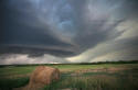
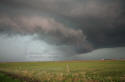
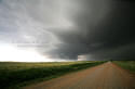
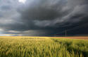
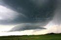
Supercell - Eagle Pass TX
5-15-2008 (d)
An isolated supercell that formed in Mexico moves eastward into south Texas.
|
|

|
|
Purple Sunset - Big Bend, TX
5-17-2008 (d)
Purple mountain majesty in the fading light after sunset. |
|
|
|
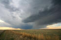
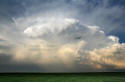
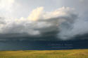
Plains Thunder - Stoneham, CO
5-20-2008 (d)
A supercell slowly develops over the open plains of eastern Colorado. |
|
|
|
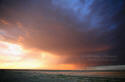
Stormy Sunset - Buckingham, CO
5-20-2008 (d)
The setting sun paints a colorful scene over the western high plains. |
|
|
|
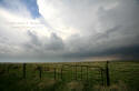
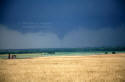
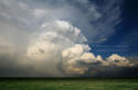
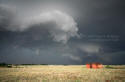
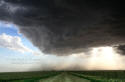
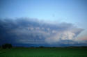
Supercell - Scott City, KS
5-22-2008 (d)
A pre-tornadic storm rapidly explodes over western Kansas. |
|

|
|
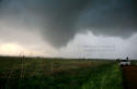
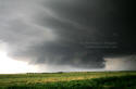
Wall Cloud - Trego Center, KS
5-22-2009 (d)
A large wall cloud forms prior to the developement of a rain-wrapped tornado. |
|
|
|
|
|
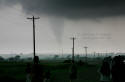
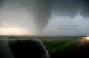
Tornado 1 - Hennessey, OK
5-24-2008 (d)
The first ghostly tornado appears to our west near Hennessey, OK. |
|
|
|
Tornado 2 - Hennessey, OK
5-24-2008 (d)
One of numerous tornadoes forms from an isolated storm in northern Oklahoma. |
|
|
|
Tornado A - Perry, OK
5-24-2008 (d)
Chasers scramble to get into position just as a tornado begins to develop. |
|

|
|
Tornado B - Perry, OK
5-24-2008 (d)
A fat cone-shaped tornado begins to descend to the ground. |
|
|
|
Tornado C - Perry, OK
5-24-2008 (d)
Storm Chasers point to a descending tornado that looms ever closer. |
|
|
|
Tornado D - Perry, OK
5-24-2008 (d)
Preparing to leave as the approaching tornado becomes rain-wrapped. |
|
|
|

|
|
Tornado E - Perry, OK
5-24-2008 (d)
One last photo of the approaching tornado before heading east. |
|

|
|
Storms & Wires - Western, KS
5-25-2008 (d)
These weathered old telephone poles seem to brace against yet another storm. |
|

|
|
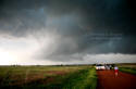
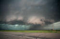
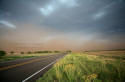
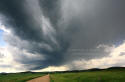
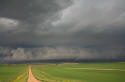
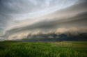
Gust Front - Western KS
5-25-2008 (d)
A lonely Kansas farm road leads to an approaching storm. |
|

|
|
Quiet Storm - Willow, OK
5-27-2008 (d)
A weak storm drifts across the western sky of Oklahoma. |
|

|
|
LP Storm - Willow, OK
5-27-2008 (d)
A small LP (Low Precipitation) storm in OK. |
|

|
|
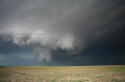
Mesocyclone - Kearney, NE
5-29-2008 (d)
A supercell tightens up its updraft base west of Kearney, NE. |
|
|
|
|
|
Mesocyclone b - Kearney, NE
5-29-2008 (d)
Pre-tornadic conditions west of Kearney, NE |
|
|
|
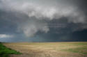
Mesocyclone c - Kearney, NE
5-29-2008 (d)
A tornado is imminent as dust whirls form beneath the rotating wall cloud. |
|
|
|
Tornado - Kearney, NE
5-29-2008 (d)
A hidden rain-wrapped tornado ahead of the "clear slot" plows through Kearney, NE. |
|

|
|
Towers & Rays - Eastern KS
5-30-2008 (d)
Cloud shadows from the setting sun reach for the sky. |
|

|
|
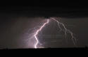
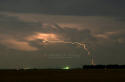
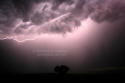
Lightning - Stoneham, CO
6-02-2008 (d)
A distant storm begins to produce lightning well after sunset. |
|

|
|
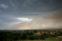
Dusty Storm - Healy, KS
6-03-2008 (d)
Gusty outflow kicks up dust below a colorful storm near sunset. |
|
|
|

|
|
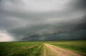
Storm Front - Logan County, KS
6-03-2008 (d)
Linear Storms in Kansas begin kicking out dusty outflow winds. |
|

|
|
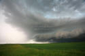
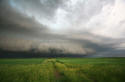
Shelf Cloud - Logan County, KS
6-03-2008 (d)
A shelf cloud looms over two travel routes in rural Kansas. |
|

|
|
HP Supercell - Yuma, CO
6-04-2008 (d)
A High Precipitation (HP) supercell approaches from the west. |
|

|
|
HP Supercell a - Yuma, CO
6-04-2008 (d)
A heavy rain and hail core fall from the base of the approaching storm. |
|
|
|
HP Supercell b - Yuma, CO
6-04-2008 (d)
The hail and rain core approach the town of Yuma, CO |
|
|
|
Hail Drifts - Yuma, CO
6-04-2008 (d)
Hail drifts clog the streets as a new storm approaches from the west. |
|
|
|

|
|
Hail Drifts 2 - Yuma, CO
6-04-2008 (d)
Two-foot deep hail drifts line the streets as a second storm approaches Yuma. |
|
|
|
Supercell 1 - Wray, CO
6-04-2008 (d)
A departing supercell fills the eastern horizon. |
|
|
|
Supercell 2 - Wray, CO
6-04-2008 (d)
A strong updraft region is evident in this departing supercell near Wray, CO. |
|

|
|
Whale's Mouth - Great Bend, KS
6-05-2008 (d)
The ragged underside of the updraft base precedes a heavy rain core. |
|

|
|
Wall Cloud - Reydon, OK
6-08-2008 (d)
A small wall cloud forms above a sun lit wheat field. |
|
|
|
Supercell - Sweetwater, OK
6-08-2008 (d)
The very low base of the supercell appears to hug the ground. |
|
|
|

|
|
Supercell a - Sweetwater, OK
6-08-2008 (d)
A ground hugging wall cloud in northwestern Oklahoma. |
|
|
|
Supercell b - Sweetwater, OK
6-08-2008 (d)
A large wall cloud below a tail-end supercell begins to rotate. |
|
|
|
Supercell c - Sweetwater, OK
6-08-2008 (d)
A rain-imbedded CG strikes below a tornado-warned storm. |
|

|
|
CG Fire - Sweetwater, OK
6-08-2008 (d)
Smoke created by a lightning started fire just ahead of a developing tornado. |
|

|
|
Tornado - Sweetwater, TX
6-08-2008 (d)
A brief tornado forms just ahead of a region of strong outflow.. |
|
|
|
Gust Front - Berlin, OK
6-08-2008 (d)
A gust front from a severe-warned storm approaches from the west. |
|
|
|

|
|
Lightning 1 - Berlin, OK
6-08-2008 (d)
A lightning strike (CG) in western Oklahoma lights up the cloud base. |
|

|
|
Lightning 2 - Berlin, OK
6-08-2008 (d)
A lightning strike illuminates cloud material that is close to the ground. |
|
|
|
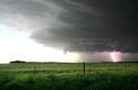
Lightning 1 - Wheeler, TX
6-08-2008 (d)
A close lightning bolt reigns down from a nighttime thunderstorm. |
|

|
|
Lightning 2 - Wheeler, TX
6-08-2008 (d)
Nighttime lightning beneath a wall cloud in the Texas Panhandle. |
|

|
|
Supercell - Southeast KS
6-12-2008 (d)
A supercell gathers strength over a Kansas wheat field. |
|
|
|
HP Supercell - SE Kansas
6-12-2008 (d)
A messy wet supercell fills the western sky over Kansas. |
|
|
|

|
|
HP Supercell - SE Kansas
6-12-2008 (d)
A large rain and hail core is clearly visible beneath this wet supercell. |
|
|
|
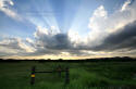
Sun Rays - Lawton, OK
6-13-2008 (d)
Convective clouds in front of the sun cast shadows across the sky. |
|

|
|
Lightning 1 - Frederick, OK
6-13-2008 (d)
Lightning illuminates a distant cumulonimbus cloud. |
|
|
|
Lightning 2 - Frederick, OK
6-13-2008 (d)
Lighning arcs out of the parent thunderstorm on its way to the ground. |
|

|
|
Towering Cu - Groom, TX
6-14-2008 (d)
A towering cumulus (TCu) builds skyward! |
|

|
|
Hail Core - Groom, TX
6-24-2008 (d)
A rain and hail core being blown outward by strong outflow winds. |
|
|
|
|
|
Storm's Coming - Brice, TX
6-14-2008 (d)
A storms outflow of rain and hail approaches an abandoned homestead. |
|

|
|
Stormy Rainbow - Flomat, TX
6-14-2008 (d)
A rainbow forms behind an old work shed in the Texas Panhandle. |
|
|
|
Dusty Outflow - Brice, TX
6-14-2008 (d)
Winds blowing over dry red clay fields create hazardous driving conditions. |
|
|
|
Cold Pool - Turkey, TX
6-14-2008 (d)
Airbourne dust defines a storm's cold-pool outflow. |
|

|
|
Lightning - Floyadada, TX
6-14-2008 (d)
Lightning from a developing thunderstorm over the Texas Panhandle. |
|

|
|
RFB & Cows, Beaver, OK
6-15-08 (d)
Cows gather below the Rain Free Base of a developing thunderstorm. |
|
|
|
|
|
Tornadic Supercell - Booker, OK
6-15-2008 (d)
Brief tornadic whilrls were observed in the dusty circulation beneath this supercell. |
|

|
|
Sunset Supercell - Booker, OK
6-15-2008 (d)
A distant supercell is illuminated by the setting sun. |
|

|
|
Farmstead - Clayton, NM
6-17-08 (d)
A New Mexico farmstead in the shadow of an approaching storm. |
|

|
|
Scud Bomb - Clayton, NM
6-17-2008 (d)
Ominous scud clouds form near rain-cooled storm outflow winds. |
|

|
|
Kelvin-Helmholtz Kearney, NE
6-18-2008 (d)
Kelvin-Helmholtz "wave" clouds form in the turbulent air near a severe storm. |
|

|
|
Rainbow Arc 1 - Kimball, NE
6-19-2008 (d)
A small shaft of sun light produces a tiny rainbow along the horizon. |
|
|
|

|
|
Rainbow Arc - Kimball, NE
6-19-2008 (d)
A small rainbow steals the show below a large thunderstorm base. |
|

|
|
Rainbow Arc 3 - Kimball, NE
6-19-2008 (d)
A ray of sun light illuminates a rain-shaft and produces a small rainbow. |
|

|
|
Rainbow Cu - Sidney, NE
6-19-2008 (d)
A rainbow can be seen in a newly developed rain shaft. |
|
|
|
Distant Thunder - Sunol, NE
6-19-2008 (d)
A sun lit field contrasts a fast approaching severe thunderstorm. |
|

|
|
Severe Storm - Sunol, NE
6-19-2008 (d)
The leading edge of an ominous looking storm fills the western sky. |
|

|
|
Pretty Storm - Potter, NE
6-19-2008 (d)
Pretty storm clouds loom above a barren landscape. |
|
|
|
|
|
Wind Sculpted 1 - Potter, NE
6-19-08 (d)
Wind sculpted cloud shapes above the Nebraska landscape. |
|

|
|
Wind Sculpted 2- Potter, NE
6-19-2008 (d)
Wind sculpted cloud shapes above the Nebraska landscape. |
|

|
|
Wind Sculpted 3 - Potter, NE
6-19-2008 (d)
Wind sculpted cloud shapes above the Nebraska landscape. |
|

|
|
Last Glow 1- Potter, NE
6-19-2008 (d)
A departing supercell displays a final show before nightfall. |
|

|
|
Last Glow - 2 - Potter, NE
6-19-2008 (d)
A departing supercell displays a final show before nightfall. |
|
|
|
Last Glow 3 - Potter, NE
6-19-2008 (d)
A departing supercell displays a final show before nightfall. |
|
|
|

|
|
Windmill - Sioux County, NE
6-22-2008 (d)
A weathered windmill stands firm against a stormy backdrop. |
|

|
|
LP Storm - Hemingford, NE
6-22-2008 (d)
A Low Precipitation storm weakens and drifts slowly eastward. |
|

|
|
Classic Supercell - Rapid City, SD
6-23-2008 (d)
Classic supercell structure rises above the Black Hills of South Dakota. |
|

|
|
Billowing Clouds - South Dakota
6-23-2008 (d)
Billowing clouds dwaft a lone tree on the nearly treeless plain. |
|

|
|
LP Supercell 1- Hermosa, SD
6-23-2008 (d)
A twisted supercell forms over the Black Hills of South Dakota. |
|
|
|
LP Supercell 2 - Hermosa, SD
6-23-2008 (d)
Spiral cloud bands stream well ahead of the storm's updraft area. |
|
|
|

|
|
LP Storm - Fairburn, SD
6-23-2008 (d)
A suction cup updraft base below a pretty Low Precipitation storm. |
|
|
|
LP Storm 2- Fairburn, SD
6-23-2008 (d)
Turning of clouds with height is apparent in this Low Precipitation storm. |
|

|
|
Colorful Lightning - South Dakota
6-23-2008 (d)
A colorful lightning strike illuminates the nighttime sky over South Dakota. |
|
|
|
CC Lightning - South Dakota
6-23-2008 (d)
A Cloud to Cloud lightning bolt illuminates the underside of the storm's base. |
|

|
|
Forked Lightning - South Dakota
6-23-2008 (d)
A large and close CG strike comes dangerously close to the photographer! |
|

|
|
Towering Cumulus - Slope County, ND
6-24-2008 (d)
Convective clouds portend stormy conditions for the high plains of ND. |
|
|
|

|
|
Old House - Regent, ND
6-24-2008 (d)
A weathered old house soon to be battered by yet another storm. |
|

|
|
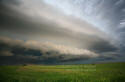
Shelf Cloud nw - Dickinson, ND
6-24-2008 (d)
Looking northwest at a large shelf cloud pushing southward towards the viewer. |
|

|
|
Shelf Cloud ne - Dickinson, ND
6-24-2008 (d)
The eastern edge of a large shelf cloud which is moving towards the viewer. |
|

|
|
Shelf Cloud north - Dickinson, ND
6-24-2008 (d)
A wider view to the north at a large shelf cloud. |
|

|
|
Shelf Cloud ne2 - Dickinson, ND
6-24-2008 (d)
A wider view of the shelf cloud looking to the northeast. |
|
|
|
Stormy Road - Lefor, ND
6-24-2008 (d)
A gravel farm road appears to lead directly to the heart of the storm. |
|
|
|

|
|
Old Farmstead - Lefor, ND
6-24-2008 (d)
A stormy view of an old abandoned farmstead near Lefor, ND. |
|

|
|
Storms & Flowers - Lefor, ND
6-24-2008 (d)
A distant storm offers stark contrast to a pretty field of flowers. |
|

|
|
Storm Sheltered - Lefor, ND
6-24-2008 (d)
The valley and the trees help to shelter this old farm. |
|
|
|
Shelf Cloud 1 - Burt, ND
6-24-2008 (d)
Looking west at a large shelf cloud moving in from the north. |
|
|
|
Shelf Cloud 2 - Burt, ND
6-24-2008 (d)
An old farm building appears to soon be swallowed by the approaching storm. |
|

|
|
Banded Shelf 1 - McLaughlin, SD
6-24-2008 (d)
Looking southwest at a beautiful banded sheld cloud apporaching Mobridge, SD |
|
|
|

|
|
Banded Shelf 2 - Mclaughlin, SD
6-24-2008 (d)
Looking northwest at a beautiful banded sheld cloud apporaching Mobridge, SD |
|
|
|
Banded Shelf 3 - McLaughlin, SD
6-24-2008 (d)
Looking southwest as a shelf cloud looms ever closer. |
|

|
|
Banded Shelf 4 - McLaughlin, SD
6-24-2008 (d)
Looking northwest as a shelf cloud looms ever closer. |
|
|
|
Banded Shelf 5 - McLaughlin, SD
6-24-2008 (d)
Dust can be seen kicking up beneath a fast approaching gust front. |
|

|
|
Mesocyclone - Thunderhawk, SD
6-24-2008 (d)
A rotating updraft beginning to get undercut by cold outflow. |
|

|
|
Multiple CG - Alzada, MT
6-25-2008 (d)
Cloud to ground lightnng in Montana. |
|
|
|

|
|
Nighttime CG's - Alzada, MT
6-25-2008 (d)
Pretty cloud to ground lightning in Montana. |
|

|
|
Nightime CG's 2 - Alzada, MT
6-25-2008 (d)
Intense cloud to ground lightning featuring fine branching. |
|

|
|
Nighttime CG's 2 - Alzada, MT
6-25-2008 (d)
A very close cloud to ground lightning strike fills the camera's frame! |
|

|
|
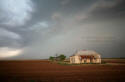
After the Storm - Kilgore, NE
6-26-2008 (d)
After the storm, a battered barn and tree bask in the late day sunlight. |
|

|
|
Cloud Shadows - Crookston, NE
6-26-2008 (d)
Razor straight cloud shadows stream across the late day sky of Nebraska. |
|

|
|
Mammatus - Kilgore, NE
6-26-2008 (d)
A weak mammatus field fills the sky above an old Nebraska grain silo. |
|
|


